

Google Maps is getting a new feature that enhances user location accuracy in tunnels through the use of “Bluetooth sensors” known as BLE technology transmitters, which transmit your identifier to nearby mobile devices for proximity-based actions.
Google Maps has introduced a new function that utilizes Bluetooth sensors.
When Google Maps includes a tunnel in the route, issues often arise because cell phone GPS signals cannot reach underground. Fortunately, there is a solution to this problem: using “bluetooth sensors”.
Bluetooth sensors placed strategically inside tunnels enhance GPS accuracy by scanning the positioning.
This technology is utilized in certain shopping centers globally. The Bluetooth sensor functionality of the Waze app is already present in cities such as New York, Chicago, Paris, Rio, Brussels, Oslo, Sydney, Boston, Mexico City, and more.
Launch and release dates
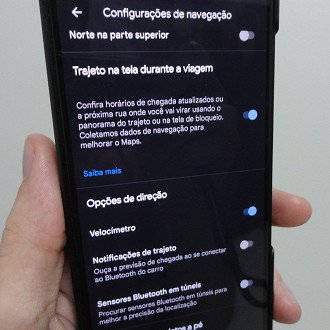
The latest precision improvement feature in Google Maps is now available to all users but is turned off as the default setting. To enable it, navigate to “Settings” > “Setting Settings” > Bluetooth sensors in tunnels. Keep in mind that Bluetooth sensors must be present in your city’s tunnels for this feature to function.